Deadly Hurricane Ian was downgraded to Tropical Storm Ian on Thursday morning but was still dumping record amounts of rain to bring “catastrophic flooding” across Florida while still packing damaging winds across a 415-mile swath of the state.
President Biden declared a major disaster for the state and Gov. Ron DeSantis is slated to give an update from the state Emergency Operations Center in Tallahassee at 8:45 a.m.
Advertisement
“The Coast Guard has been performing rescue missions on the barrier islands consistently since the wee hours of the morning,” he said. “We’ve also been working with hospitals overnight who’ve been on generator power. We’re in the process of evacuating two healthcare facilities.”
He said the power outages in Southwest Florida is intense.
Advertisement
“Lee and Charlotte are basically off the grid at this point,” he said saying power restoration will take time. “Charlotte and Lee reconnects are really going to likely have to be rebuilding of that infrastructure.”
Rising floodwaters stranded vehicles across Central Florida and law enforcement in Volusia County reported the area’s first death while the statewide toll has yet to be determined after hurricane’s storm surge devastated the Gulf Coast.
“While I don’t have confirmed numbers, I know the fatalities are in the hundreds,” said Lee County Sheriff Carmine Marceno on ABC’s “Good Morning America” this morning. Lee County was ground zero for Hurricane Ian’s landfall on Wednesday afternoon.
DeSantis, though, said at this point there were only two unconfirmed fatalities in the state.
“None of that is confirmed. I think what that is is there were 911 calls for people saying, ‘Hey, the water is rising in my home. I’m gonna go up in the attic but I’m really worried.’ Of course those folks are now again to be going to be checked on, and so I think you’ll have more clarity about that in the next day or so,” DeSantis said. “We’re obviously hoping that they can be rescued at this point.”
Reports of people trapped in homes continued to flow in overnight while destruction has included washed out bridges, the roof of a hospital intensive care unit and flooded highways.
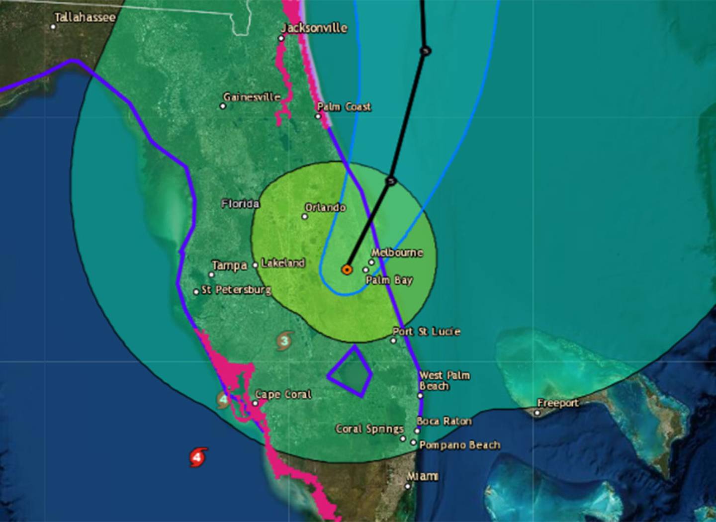
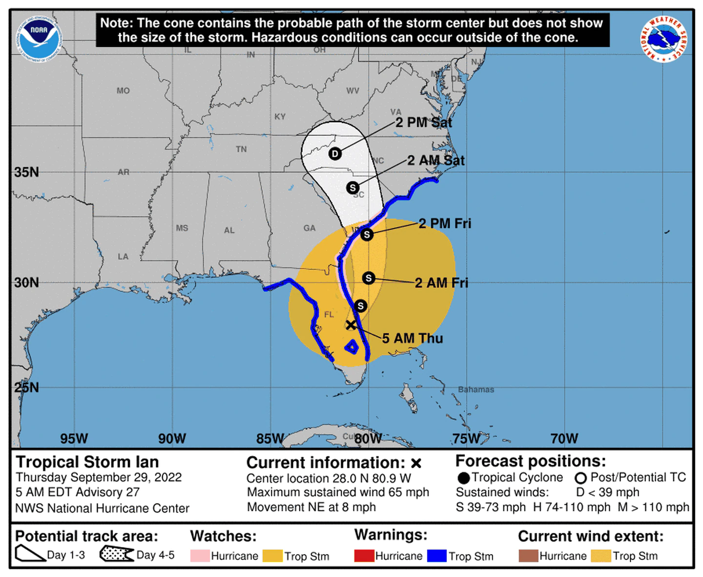
In the National Hurricane Center’s 8 a.m. update, the system’s center was located in Brevard County about 40 miles east of Orlando moving toward Cape Canaveral at 8 mph with 65 mph sustained winds and higher gusts.
Rain totals approaching 20 inches were forecast across parts of the peninsula prompting flash flood warnings across Central Florida while more than 2.6 million people were without power across the state by 8 a.m.
Advertisement
The storm that made landfall Wednesday afternoon as a massive Category 4 hurricane after lashing southwest Florida with 155 mph winds, only dropping speed as it carved its way inland moving northeast through the state overnight. At 2 a.m. it was still rated a Category 1 hurricane with 75 mph winds.
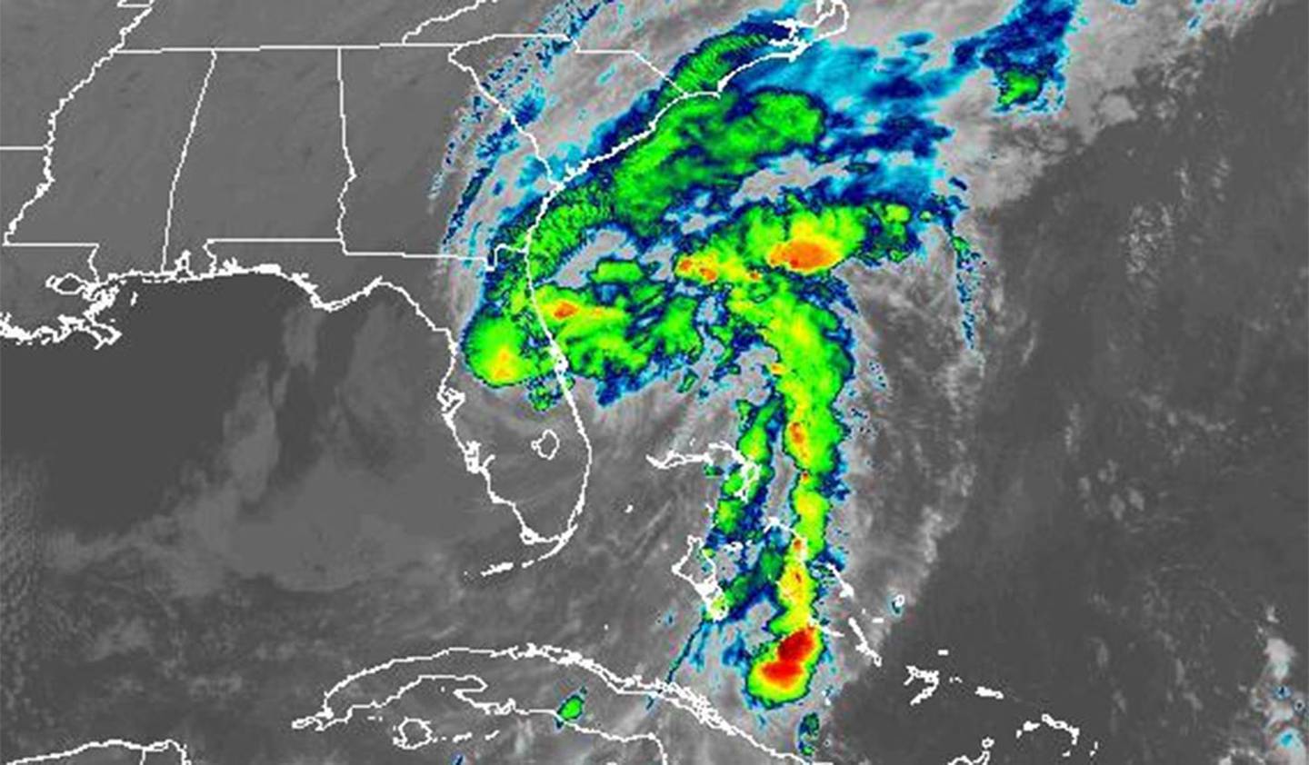
“Widespread, life-threatening catastrophic flooding, with major to record river flooding, will continue today across portions of Central Florida with considerable flooding in northern Florida, southeastern Georgia and eastern South Carolina expected today through the end of the week,” said NHC senior hurricane specialist Robbie Berg.
The National Weather Service in Melbourne issued an updated Flash Flood Warning through 8:45 a.m. as the Little Wekiva River was already a foot higher than record levels.
“We are now at historic level never been at this point in recorded history,” said Alan Harris, chief administrator for the Office of Emergency Management.
At 6:39 a.m., radar and rain gauges indicated heavy rain falling in Little Wekiva River showing between 6-10 inches with another 3-5 inches possible. The flash flooding could affect parts of Altamonte Springs, Maitland, Lake Mary, Longwood, Wekiva Springs, Forest City, Fern Park and Heathrow.
“This is a particularly dangerous situation. Seek higher ground now!” reads the warning. “Do not attempt to travel unless you are fleeing an area subject to flooding or under an evacuation order. Turn around, don`t drown when encountering flooded roads. Most flood deaths occur in vehicles.”
Advertisement
Other flash flood warnings continue in Central Florida as well including southeastern Orange County and north central Osceola County through 8:45 a.m.
“Local law enforcement reported heavy rain in the Orlando metro. Between 10 and 15 inches of rain have fallen. Additional rainfall amounts of 2 to 4 inches are possible in the warned area. Flash flooding is already occurring,” the NWS stated.
Even a section of Florida’s Turnpike has been shut down because of flooding, according to the Florida Highway Patrol.
Volusia County law enforcement reported an overnight death of a 72-year-old Deltona man who had gone outside during the storm to drain his pool.
“Deputies responded to a home on Poinciana Lane near Lake Bethel around 1 a.m. after the victim’s wife reported he disappeared after heading outside. While searching for him, deputies found his flashlight, then spotted the victim unresponsive in a canal behind the home,” according to a press release from the Volusia County Sheriff’s Office.
“On the forecast track, the center of Ian is expected to move off the east-central coast of Florida later today and then approach the coast of South Carolina on Friday. The center will move farther inland across the Carolinas Friday night and Saturday,” hurricane center forecasters said.
Advertisement
“Some slight re-intensification is forecast, and Ian could be near hurricane strength when it approaches the coast of South Carolina on Friday. Weakening is expected Friday night and Saturday after Ian moves inland.”
Winds have been increasing across Central Florida since midnight. Orlando International Airport reported a gust of 57.5 mph just before 2 a.m., while Patrick Space Force Base had a gust of 61 mph.
Power outages hit Southwest Florida the hardest including most residents of hard-hit DeSoto, Charlotte, Lee and Collier counties, according to poweroutage.us. By 8 a.m. about 650,000 people were without power in Central Florida.
The National Hurricane Center said the eye of the Category 4 hurricane made landfall near Cayo Costa State Park at 3:05 p.m. just north of Sanibel and Captiva Islands after its eyewall lashed residents in Charlotte and Lee counties for the last several hours.
The system had been pummeling the coast with near Category 5 sustained winds of 155 mph with higher gusts most of Wednesday.
After passing over the barrier island and moving up through Charlotte Harbor in a similar path to 2004′s Hurricane Charley that also carved its way into Central Florida, the still Category 4 hurricane made its second landfall close to Punta Gorda near Pirate Harbor at 4:35 p.m. with sustained winds of 145 mph.
Advertisement
Thursday morning, President Biden declared a major disaster in Florida, making millions in emergency recovery aid available, especially to the nine counties hit hardest.
“The President’s action makes Federal funding available to affected individuals in the counties of Charlotte, Collier, DeSoto, Hardee, Hillsborough, Lee, Manatee, Pinellas, and Sarasota. Assistance can include grants for temporary housing and home repairs, low-cost loans to cover uninsured property losses, and other programs to help individuals and business owners recover from the effects of the disaster,” reads part of the declaration. “For a period of 30 days from the start of the incident period, assistance for debris removal and emergency protective measures, including direct Federal assistance, is authorized at 100 percent of the total eligible costs.”
DeSantis said the state will push for more federal help.
“We have received a major disaster declaration for nine counties. but we do expect more. I just spoke with the president this morning and he offered support,” DeSantis said. “I told him thanks for this but because the storm has moved inland and caused a lot of potential damage in the center part of our state that we are going to be asking for those counties to be expanded and included there.”
Images of damage since Wednesday show a massive swatch of destruction from floodwaters and wind.
A section of the causeway leading to Sanibel Island washed away. It’s the only mode to access both Sanibel and Captiva Island from the mainland by car.
Advertisement
The barrier islands are home to more than 6,000 people.
In Port Charlotte, the storm surge flooded a hospital’s emergency room even as fierce winds ripped away part of the roof from its intensive care unit, according to a doctor who works there.
Water gushed down onto the ICU, forcing them to evacuate their sickest patients — some on ventilators — to other floors, said Dr. Birgit Bodine of HCA Florida Fawcett Hospital. Staff members used towels and plastic bins to try to mop up the sodden mess.
The medium-sized hospital spans four floors, but patients crowded into two because of the damage, and more were expected with people injured from the storm needing help.
“As long as our patients do OK and nobody ends up dying or having a bad outcome, that’s what matters,” Bodine said.
Law enforcement officials in nearby Fort Myers received calls from people trapped in flooded homes or from worried relatives. Pleas were also posted on social media sites, some with video showing debris-covered water sloshing toward the eaves of their homes.
Advertisement
Brittany Hailer, a journalist in Pittsburgh, contacted rescuers about her mother in North Fort Myers, whose home was swamped by 5 feet of water.
“We don’t know when the water’s going to go down. We don’t know how they’re going to leave, their cars are totaled,” Hailer said. “Her only way out is on a boat.”
As of 5 a.m. Thursday, Ian had dumped so much rain across Central Florida that flash flood warnings continue for parts of Orange, Osceola, Seminole, Brevard and Volusia counties.
The torrential rain earlier prompted the weather service to issue a Flood Warning for the St. Johns River near and above Lake Harney in Seminole County, saying that record flood stage coming.
“As Hurricane Ian moves into east central Florida early this morning, historic heavy rainfall will continue, leading to quickly rising levels on the Saint Johns River Above Lake Harney at Geneva,” the NWS said in its warning just after 11 p.m. Wednesday.
River levels were approaching or surpassing flood stage and record heights across the state by Thursday morning, according to measurements from the NWS.
Advertisement
By 5 a.m. Peace River near Zolfo Springs in Hardee County was approaching 26 feet in depth more than 9 feet higher than flood stage. Other rivers cresting across the state included the Ocklawaha, Myakka and Little Manatee rivers.
In Central Florida, portions of the St. Johns were approaching 3 feet over flood stage while the Little Wekiva River had risen more than 6 feet than normal surpassing flood stage.
“Heavy rainfall will continue this morning from Osceola and Brevard Counties northward, along and north of the track of Ian’s center,” the NWS said as of 5 a.m. “Additional rainfall amounts of 1 to 2 inches are expected in southern Lake, Orange and northern Osceola and Brevard Counties, 3 to 5 inches in Seminole and northern Lake Counties, and up to between 5 and 10 inches in Volusia County.”
Gov. Ron DeSantis spoke after landfall noting that some who stayed behind in the evacuation zones are calling for rescue now, but he warns the response will be delayed.
“We know that there are folks who are in the really high with risk zone A evacuation zones, who did not evacuate,” he said. “Some have called in, and those people are being logged and there will be a response, but it’s likely going to take a little time for this storm to move forward so that it’s safe for the first responders to be able to do.”
He said the intensity of the storm will only fall behind the Labor Day Hurricane of 1935, 1992′s Hurricane Andrew and 2018′s Hurricane Michael in the state of Florida, saying that on review, the NHC may even upgrade it to a Category 5.
Advertisement
“At a minimum, it’s going to be a very strong Category 4 that’s going to rank as one of the top five hurricanes to ever hit the Florida peninsula,” he said.
He said while its path is similar to Hurricane Charley, its effects will be much more vast.
“You can compare Charley to this. This is way, way, way bigger than Charley,” he said. “It was as strong as Charley coming in, but Charlie was much smaller. So this is a big one. I think we all know there’s going to be major, major impacts.”
He noted Hurricane Irma in 2017, which affected a large portion of the state, saw many more deaths after the storm passed, 77 compared to 7 from the storm itself, and warned again for residents to stay safe and avoid hazards.
“A lot of that is standing water, downed power lines, misuse of generators, so please just take precaution,” he said.
Earlier Wednesday, the National Weather Service in Tampa posted an “Extreme Wind Warning” for parts of Manatee, Charlotte, Lee, DeSoto and Sarasota counties.
Advertisement
“You need to get into the interior of your home and begin to brace for a period of sustained damaging, potentially devastating winds,” said Rhome. “Do not venture outside at all. do not try to evacuate at this point. you really have to get into the interior of your house and ride this part out.”
State Division of Emergency Management Director Kevin Guthrie warned those enduring the high winds to not venture outside if the weather suddenly clears.
“You’re most likely to have bright sunshiny area here very soon. You’re in the eye of the storm,” he said. “Stay inside, stay indoors. Do not go outside. … That eyewall will collapse, so please stay safe.”
NWS Meteorologist Cassie Leahy said Orange, Seminole and Osceola counties should expect hurricane conditions, with sustained winds of 50 to 70 mph and gusts of 90 to 100 in the evening and overnight. In Lake County, the prediction was slightly better: gusts of 75 to 80 mph.
Leahy said the biggest worry for the Orlando area was not be the wind, but the water.
“That is our biggest concern, even with as high as the winds are going to be,” she said. “We’re expecting it could be historic flooding for sure, especially across the rivers up there. … People need to be prepared that this could be historic flooding that they haven’t seen.”
Advertisement
About 12 to 18 inches of rainfall is expected across the region with local highs up to two feet, Leahy said.
Rhome encouraged those in Central Florida to not wait before hunkering down with heavy rains coming.
“Absolutely the I-4 corridor is a high risk of very heavy rain, that will produce flash flooding, impassable roads,” he said. “I’m telling you, you just need to get where you’re going, to stay and plan to be there. We lose so many people after a storm because they get out and wander about it, drive into flooded roads, powerlines might be down they just encounter. I know you want to see what happened. I know you want to see if your house, your neighborhood is OK. But please stay inside until conditions allow you to safely move about.”
[ Where to find hurricane shelters in Central Florida ]
DeSantis issued a major disaster declaration for all 67 counties to seek the federal government to reimburse 100% of upfront costs from the first 60 days after Ian’s landfall “to ensure that we can quickly recover and move forward into the response and recovery part.”
DeSantis also said he was “appreciative of the Biden administration for responding in this time of need.”
He said there are more than 250 aircraft, more than 1,600 high water vehicles and more than 300 boats of all drafts and sizes to be used in recovery efforts such as delivering supplies.
Advertisement
“I want to say thanks a lot of people who offer thoughts and prayers for the folks that are in the eye of the storm and that means a lot to us,” he said. “There’s also people that want to be able to do their part.”
To that end DeSantis directed the activation of the Florida Disaster Fund so people can donate funds rather than sending items.
“We have everything we need in terms of the immediate response needs, but there will be thousands of Floridians who will need help rebuilding,” he said.
To contribute people can visit www.FloridaDisasterFund.org or text “disaster” to 20222.
DeSantis asked residents to stay off the roads since thousands of line workers and other help from 26 states are poised and ready to go, and the Florida Department of Transportation will be out clearing roads of debris.
“If you are on the roads you are putting your lives in danger,” he said.
Advertisement
Live images from Sanibel Island webcams showed some streets flooded up to mailboxes after Ian’s visit.
There are several webcams available up and down the Gulf Coast that showed the impacts of Ian as it moved ashore including from the Naples Pier, Sunshine Skyway Bridge in Tampa, Fort Myers Beach and Englewood.
“Clearly, this is a very powerful major hurricane that’s going to have major impacts, both on impact in southwest Florida, but then as it continues to work through the state,” DeSantis said from the state Emergency Operations Center in Tallahassee Wednesday morning. “It is going to have major, major impacts in terms of wind, in terms of rain, in terms of flooding, so this is going to be a nasty, nasty day — two days.”
Other posts showed surge flooding neighborhoods in Naples, Bonita Springs and Fort Myers onshore.
Some show water levels up to the roofs of homes.
Posts from Naples are beach resorts showed cars being washed away and debris floating among the grounds outside the flooded ground floors.
Advertisement
The storm may have claimed the lives of several Cuban migrants whose vessel sunk in the Florida Straits near the Florida Keys, according to the U.S. Coast Guard.
The USGS stated that after four migrants made it to shore near Block Island, a search for the remaining 23 began.
“Crews rescued three people in the water about 2 miles south of Boca Chica,” the USGS stated on Twitter. “They were brought to the local hospital for symptoms of exhaustion and dehydration. Air crews are still searching.”
DeSantis also appeared Wednesday with power company linemen awaiting deployment during a press conference in Lake City noting the storm was likely to bring tragic results.
“So just understand the impact of the storm is going to be enormous,” he said. “There’s obviously some people who are in harm’s way by choice having hunkered down in their areas and we’re praying for them. Obviously there’s going to be rescue efforts made as soon as it’s safe to do so. … It’s going to be going to be a tragic event in many ways. But it’s something that we’re going to dig in on. We’re going to be there. We’re going to stand with the people who are most affected.”
DeSantis gave a sobering view of how the storm will be remembered.
Advertisement
“I would just say it seems like over the last 12 to 24 hours every time you look at this storm, it’s just been bad news. It gets stronger, larger,” he said. “This is a really, really significant storm. It will be one of the storms people always remember when they think about Southwest Florida — probably be the big one. They always remember and if you know anything about our state and you go to Panama City, you know that Michael is just part of the DNA of the community. Homestead — Hurricane Andrew just part of the DNA — and this is going to rank up there with that, so we need the thoughts and prayers over the near-term, and then there’s going to be a huge effort on the back end, to help people and to get the communities back on their feet.”
“It’s going to be historic,” said National Weather Service Melbourne meteorologist Kole Fehling.
Staff writers Skyler Swisher, Katie Rice, Ryan Gillespie, Austin Fuller, Nelly Ontiveros, Stephen Hudak, Leslie Postal, Amanda Rabines, the Sun Sentinel and The Associated Press contributed to this report.